Where is the city of Sakarya located? How far is Sakarya from Istanbul? These questions appear in the minds of tourism visitors in Turkey, as Sakarya is one of the most beautiful cities in Turkey and one of the most important tourist destinations that are characterized by fascinating views, and it is one of the dazzling options for those who love tourism in Turkey.
We decided to know the location of the city of Sakarya in Turkey to facilitate the fans of the city, and we will also show you the distance that the city of Sakarya is from the neighboring cities.
Table of Contents
SCARIA hotels
If you are planning to travel to the tourist city of Sakarya, you should know the nearest hotels from the tourist places you want to visit, which provide tourists with the best possible services, but for the many luxurious hotels we have collected the best Sakarya hotels in the following report .. Read more

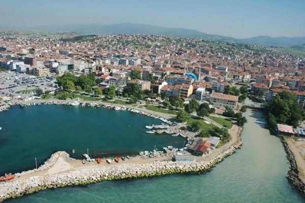
Where is Sakarya located on the map:
Sakarya is located in the northwestern side of the state of Turkey, specifically in the Marmara region, which overlooks the coasts of the Black Sea, and it is divided into two parts by the Sakarya River.
But where is Sakarya located in Turkey on the map, note the location of Sakarya with us according to Google Maps:
The most important cities near Sakarya:
After we got acquainted with the location of Sakarya on the map, let us move to know how far Sakarya is from Istanbul and the distance between the city of Sakarya and the nearby cities such as: Istanbul, Sapanca, Bursa, Antalya, Trabzon, in addition to knowing how to reach it, and how many hours the journey takes from City to another.
The distance between Sakarya and Istanbul
How far is Sakarya from Istanbul? The distance between Sakarya Istanbul is about 155 km, and you can travel this distance by car within approximately two hours.
The distance between Sakarya and Sapanca
The distance between Sakarya and Sapanca is about 18 km, as it is one of the closest cities to Sakarya. The journey takes about 21 minutes by car, but there are fees to be paid when moving between the two cities.
The distance between Sakarya and Bursa
The distance between Sakarya and Bursa is about 183 km, and it is reached by car in a time that takes about two hours.
The distance between Sakarya and Antalya
The distance between Sakarya and Antalya is 577 km, and the distance between them is about 6 hours and 47 minutes by car.
The distance between Sakarya and Trabzon
The distance between Sakarya and Trabzon is about 934 km, and it takes about 11 and a half hours by car, but you can shorten that time and go to it by air within an hour and a half.
The distance between Sakarya and Fethiye
The distance between Sakarya and Fethiye is about 658 km, and is reached by car or bus in a time that takes 7 hours 29 minutes.
After knowing clearly how far Sakarya is from Istanbul, you can see the most important sights in Sakarya through the following article .. Read more