Ukraine is a country located in Eastern Europe, it is the second largest on the continent after Russia, and the capital is Kiev, located on the Dnieper River in the north-central of Ukraine. Ukraine visa can be extracted from the kingdom easily for travel and tourism lovers.
History of Ukraine
A fully independent Ukraine did not emerge until the late twentieth century after long periods of successive domination by Poland, Lithuania, Russia, and the USSR (United States), and Ukraine experienced a short period of independence in the period 1918–1920, but parts of western Ukraine were ruled by Poland Romenia and Czechoslovakia in the interwar period, and Ukraine subsequently became part of the Soviet Union as the Ukrainian Soviet Socialist Republic (SSR).
When the Soviet Union began to collapse in 1990-1991, the legislature of Ukraine was a Soviet socialist, and it declared sovereignty (July 16, 1990) and then full independence (August 24, 1991), a move that was confirmed by popular approval in a public referendum (December 1, 1991), With the dissolution of the United States in December 1991, Ukraine gained full independence, the country changed its official name to Ukraine, and helped found the Commonwealth of Independent States (CIS), an association of countries that were formerly Republics of the Soviet Union.
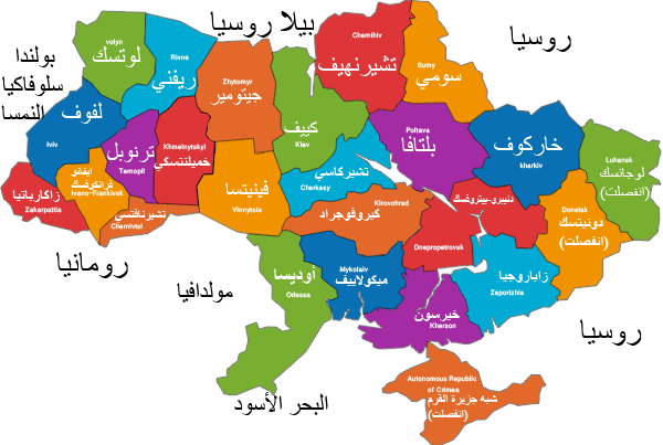
Ukraine borders
Ukraine borders Belarus from the north, Russia to the east, the Azov Sea, the Black Sea to the south, Moldova and Romenia to the southwest, Hungary, Slovakia, and Poland to the west, and in the far southeast, Ukraine is separated from Russia by the Kerch Strait, which connects the Azov Sea with the Black Sea.
The land of Ukraine
Ukraine occupies the southwestern part of the Russian Plain (Eastern European Plain), and the entire country consists of flat plains at an average height of 574 feet (175 meters) above sea level, and there are no mountainous areas such as the Ukrainian Carpathian Mountains and the Crimean Mountains except on the borders The country barely represents 5 percent of its area, and despite that the Ukrainian landscape is characterized by some diversity as its plains are broken by the highlands, which operate in a continuous belt from the northwest to the southeast and also in the lowlands, and the Dnieper Plateau is the highlands that lie between the tributaries Central to the Dnieper River (d Nebro) and south of the Poh River (Boevdiny Poh) in the west of central Ukraine is the largest plateau region, and it is dissected by many river valleys, valleys and pathways some of which are more than 1,000 feet (300 meters) deep.
On the western side, the Dnieper Upland region is close to the rugged Volyn-Podilsk Upland, which rises to 1545 feet (471 meters) at its highest point “Kamola Mountain”, and extends west of the Volyn-Podilsk Mountains in the far western Ukraine, and the Karpath mountain ranges are One of the most picturesque areas in the country for more than 150 miles (240 km), and the height of the mountains ranges from about 2000 feet (600 meters) to about 6500 feet (2000 meters), and rises to 6762 feet (2061 meters) in Mount Hooverla which is the highest point In the country, the northeast and southeastern parts of Ukraine are occupied by the lowlands and rarely rise to 1,000 feet (300 meters) Among the country’s lowlands is Pripet Marshes (Polissya), which is located in the northern part of Ukraine and crossed by many river valleys.
In the east and central Ukraine lies the low Dnieper region, is flat in the west and rolls gently in the east. To the south, another lowland extends along the shores of the Black Sea and the Sea of Azov. Its flat surface, only broken by low elevations and shallow lows, gradually slopes toward the Black Sea. The shores of the Black Sea and the Sea of Azov are characterized by narrow, sandy spots of land flowing into the water; one of these locations, Spitt wagons, is about 70 miles (113 km) but average width less than 5 miles (8 km), and the southern lowlands continue to Crimea peninsula in the name of the lowlands of the northern Crimean peninsula, the peninsula is a large outcrop in the Black Sea, connected to the mainland by Perekop Isthmus and the Crimean Mountains form the southern coast of the peninsula, Mount Romen Kush at an altitude of 5069 feet (1545 meters) which is the highest point in the mountains.
Ukraine soil
From the northwest to the southeast, the soil in Ukraine can be divided into three main clusters, they are an area of Bodzolian sandy soil, a central belt consisting of very fertile Ukrainian black chernozems, a region of chestnut and salted soil, and the Podolese soil occupies about a fifth of the country’s area mostly in the north and northwest And, this soil was formed by extending the post-glacial forests to areas of grassy steppe, and most of this soil may be farmed although it requires adding food to obtain a good harvest.
Climate of Ukraine
Ukraine is located in a temperate climate zone affected by warm, humid moderate air from the Atlantic Ocean, and winter in the west is much milder than that in the east, and in summer on the other hand often the east faces higher temperatures than the west, and the average annual temperature ranges From around 42-45 ° F (5.5-7 ° C) in the north to about 52-55 ° F (11-13 ° C) in the south, the average temperature in January is the coldest month, and about 26 degrees Fahrenheit (-3 degrees Celsius) in the southwest and about 18 degrees Fahrenheit (-8 degrees Celsius) in smell The eastern, the average temperature in July is the hottest month, and is about 73 degrees Fahrenheit (23 degrees Celsius) in the southeast and about 64 degrees Fahrenheit (18 degrees Celsius) in the northwest.